Improvements in weather tracking technology will help states like North Carolina to anticipate dangerous storms during hurricane season. Here’s what to know.
Pull up the National Hurricane Center’s daily map and you’ll see whether tropical cyclone activity is expected within the next seven days as the 2025 hurricane season kicks off for North Carolina and other states along the Atlantic Coast.
All the North Carolina news, in 2 minutes or less, in Cardinal & Pine’s free, award-winning newsletter. Sign up here.
Twenty years ago, this 7-day outlook might have been unthinkable, but with improvements in satellites and forecast technology, meteorologists now know more than ever about when and where storms form and move. Thanks to higher resolution satellites, hurricane researchers also know more about the weather patterns that move westward across the Atlantic and Caribbean that could eventually become tropical storms or cyclones.
Known as tropical waves, these areas of low pressure – found in the atmosphere above the surface and not in the ocean – have always moved across the Atlantic and around the globe.
Forecasters are watching these waves more closely than ever and understand more about how some of them become the seeds of tropical storms and hurricanes, said Kelly Núñez Ocasio, assistant professor in the atmospheric sciences department at Texas A&M University.
As a result, the waves also catch the attention of casual observers who find their way to the page where the hurricane center’s highly trained specialists present their discussion of what’s happening across the Atlantic basin. When a tropical wave gets mentioned, there’s no immediate cause for alarm or concern.
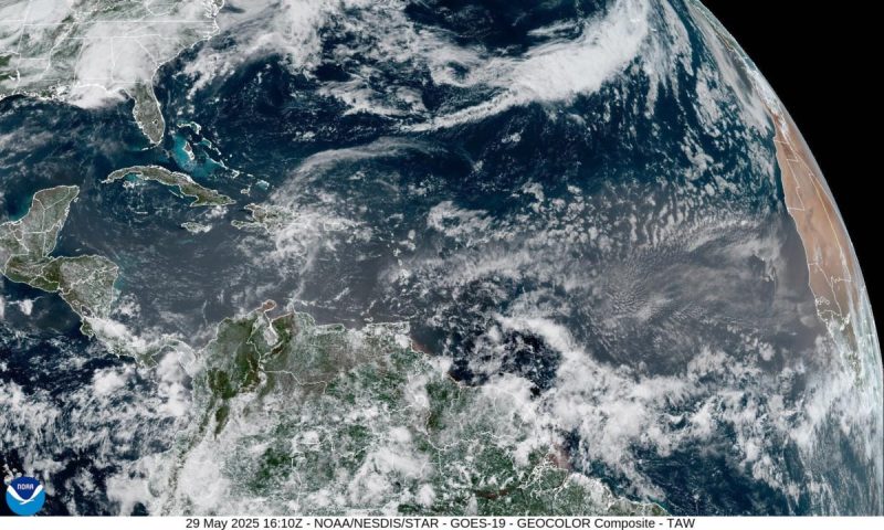
Most of the waves “aren’t very noteworthy, and about half of them are almost imperceptible,” said Chris Landsea, chief of the National Hurricane Center’s tropical analysis and forecast branch. They’re mostly found in the lower latitudes, along a band across the Caribbean south of the Florida Keys.
By themselves, the waves have little impact on states outside Florida to the north, he said. For example, ‘the (waves) we’re watching right now (on May 29, 2025) aren’t going to be impacting the U.S. at all.”
Still, it’s “very important” for the hurricane center to track tropical waves, Landsea said.
Why track tropical waves?
Even without further development, tropical waves can impact local weather by influencing thunderstorms and bringing gustier winds as they approach. The other reason to keep an eye on tropical waves is that some of the strongest that come off the African Coast tend to create the most dangerous hurricanes.
Roughly 80 tropical waves are found across the Atlantic basin in a given year, said Landsea, who has studied tropical waves for decades.
Between 40 and 60 of those emerge off the African Coast during the hurricane season that begins June 1 and ends December 1, said Núñez Ocasio. Fewer than two dozen of these waves become named tropical storms. Even fewer become hurricanes.
However, the waves are particularly important for forecasters to observe because “most of the hurricanes that get strongest originate from tropical waves,” Landsea said. An estimated 85% of the most intense hurricanes – the Category 3’s, 4’s and 5’s, with winds of 111 mph or more – get their start in the tropical waves that move off the African coast, he said.
To become a depression or storm, a tropical wave must encounter a perfect set of conditions in the surrounding ocean and atmosphere that include very warm ocean water, relatively moist air, and a potentially unstable atmosphere.
Many tropical waves form over Africa
Researchers such as Núñez Ocasio are working to answer riddles such as what makes some hurricanes larger in size than others and why some waves form hurricanes and others do not. The more they learn, the more the information can be used to improve hurricane forecast models.
The stronger waves often begin over the high mountains of Ethiopia in eastern Africa, gathering strength, size and moisture from the monsoon as they move west, said Núñez Ocasio.
A lot of “very warm air” rises over the mountains in an area where the African easterly jet stream enters the region, she said. The resulting convection produces waves that interact with the West African monsoon and the wind energy in the jet, and by the time they reach the western coast, their structure is already more suitable to become a tropical depression, she said.
It’s only been within the last few years, that researchers have been able to correlate the intensity of a wave coming off Africa with the intensity of any tropical depression it forms, she said. “Those waves that originate over the Ethiopian highlands are actually the ones more likely to become hurricanes.”
Her research proved timely last summer, when an expected busy season kind of stalled out at one point in mid-summer. A very active monsoon ranged over Africa, so intense that it was flooding areas of the Sahara Desert where flooding hadn’t been previously seen, she said. The tropical waves and the African jet were pushing farther north and not coming off the coast along the typical Atlantic hurricane track, she said.
That pattern may suggest a shift in the peak of Atlantic hurricane season in response to climate change, with waves forming and moving more slowly, and gathering more moisture, she said. “All the entire tropical atmosphere is changing …. Tropical waves are getting more intense with the changing climate.”
Learning about potential tropical systems earlier than in the past is not a reason to worry, but it can be a reason to prepare early, she said. “It’s about thinking twice, decision-making to safeguard life and property.”
Dinah Voyles Pulver, a national correspondent for USA TODAY, writes about hurricanes, violent weather and other environmental issues. Reach her at dpulver@usatoday.com or @dinahvp on Bluesky or X or dinahvp.77 on Signal.
This article originally appeared on Wilmington StarNews: With hurricane season here in NC, what to know about ‘tropical waves’
Reporting by Dinah Voyles Pulver, USA TODAY / Wilmington StarNews
USA TODAY Network via Reuters Connect