AccuWeather's forecast shows the winter storm potential for North Carolina this weekend, Saturday, Jan. 31, 2026, and Sunday, Feb. 1, 2026. (USA Today via Reuters)
These storms can produce heavy snow, strong winds, and coastal flooding, making them a major winter weather threat for areas along the Atlantic coast from North Carolina to Maine.
A strong winter weather system has the potential to develop into a bomb cyclone off the East Coast later this weekend, after spilling snow onto the Southern Appalachians.
These storms can produce heavy snow, strong winds, and coastal flooding, making them a major winter weather threat for areas along the Atlantic coast from North Carolina to Maine.
“Model trends are being closely monitored for the development of strong coastal low pressure off the Mid-Atlantic coast this weekend which could move northeastward and affect coastal New England later in the weekend,” the National Weather Service in Maine said.
Meteorologists say the storm won’t be anywhere near the size of the Jan. 23-26 storm, but its track and potential strength aren’t yet clear. Both could influence how much the system interacts with the lingering frigid air over the eastern U.S. and determine how much rain or snow falls.
Tracking the formation of the potential bomb cyclone
The system starts as an upper-level trough — a dip in the jet stream — currently over the Great Lakes and Ohio Valley, according to the Weather Prediction Center. This trough is like a conveyor belt for cold Arctic air, pushing frigid temperatures and light snow into eastern Kentucky, eastern Tennessee and the southern Appalachians Friday into Saturday, Jan. 30-31.
“A significant winter weather event is expected to impact the region from Friday night through Saturday night, with snow expected to be the primary precipitation type,” the National Weather Service office in Asheville said. “Due to cold temperatures leading up to the event, impacts to travel could be significant.”
As the trough progresses east, several atmospheric features can help the storm strengthen offshore.
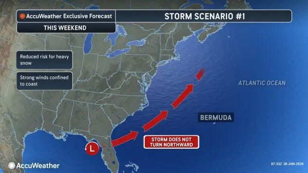
According to AccuWeather, one of two storm scenarios would see a weaker storm that didn’t turn northward, limiting snow impacts.
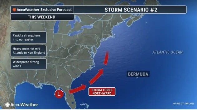
In AccuWeather’s second scenario, the storm could track closer to the coast and bring heavier precipitation over the eastern U.S.
Southern Appalachians low-level circulation
Forecasts indicate that a low-pressure area may form in the Southern Appalachians Saturday morning, Jan. 31, around 5,000 feet above the surface (the 850mb level). This feature helps increase lift and draw in moisture from the Atlantic, setting the stage for heavier snow farther east.
Upper level interactions in the Arctic
Cyclonic circulations over southeast Canada and south of Iceland create a zone where upper-level winds converge, focusing energy for the developing storm. Meanwhile, incoming Pacific shortwaves and the position of the western North America ridge influence how strongly the system can amplify once it reaches the coast.
Coastal intensification
Once the storm moves off the coast, likely over the Outer Banks, it can tap into ocean moisture and favorable upper-level winds, allowing it to rapidly deepen into a powerful coastal low — and if the pressure drops fast enough, the hallmark of a bomb cyclone — it could bring widespread impacts from the Mid-Atlantic to New England.
If it tracks close enough to the shore, the storm could produce heavy snow, gusty winds and coastal flooding from North Carolina to Maine, although the weather service isn’t currently predicting huge amounts of rain or snow in the East, but that could change.
The system could take one of three paths, Marc Chenard, a meteorologist at the prediction center, confirmed to USA TODAY. The first, and most likely, would be close to shore along the Carolinas and southeast Virginia and then out to sea, with only some impacts along the coast. It could also move along the East Coast all the way to New England, with greater impacts to land, or it could stay offshore altogether.
But forecasts emphasize that small shifts in the storm’s track or timing can dramatically change snowfall totals and wind impacts, regardless.
Will North Carolina get snow this week? North Carolina forecast
Snow amounts were nudged down a bit, but the storm is still strong enough to meet Winter Storm Warning criteria, according to the National Weather Service.
- NC/TN border areas: also 4–7 inches, likely the higher-impact zone
- Western half of the area: about 2–4 inches of snow
- Eastern half of the area: about 4–7 inches
What is a bomb cyclone?
A bomb cyclone is not a unique type of storm — it’s a label meteorologists use when a storm strengthens very rapidly, with air pressure dropping sharply over a short period of time, according to the National Oceanic and Atmospheric Administration. Think of it less as what the storm is and more as how fast it intensifies.
It’s the equivalent of rapid intensification in a hurricane, where winds jump dramatically in a short time. The rapid drop in pressure causes winds to strengthen and the storm to expand, which can produce heavy snow, strong winds and coastal flooding.
Bomb cyclones usually form when cold Arctic air collides with warmer air over the ocean. The temperature contrast gives the storm extra energy, and the jet stream often helps the air rise quickly. That rising motion accelerates the pressure drop at the surface, fueling the storm’s rapid growth. The “bomb” label comes from that fast intensification, not the snow, rain or wind itself.
Bomb cyclone vs. nor’easter: What’s the difference?
A bomb cyclone describes how fast a storm strengthens, with air pressure dropping rapidly in a short period of time. A nor’easter describes a coastal storm along the East Coast, named for its strong northeast winds.
A storm can be both if it rapidly intensifies offshore and brings classic nor’easter impacts like heavy snow, strong winds and coastal flooding.
North Carolina weather watches and warnings
A Winter Storm Watch has been issued for our entire forecast area from late Friday afternoon through Saturday night, Jan. 30-31.
Reporting by Brandi D. Addison, USA TODAY NETWORK / Asheville Citizen Times
USA TODAY Network via Reuters Connect
Author

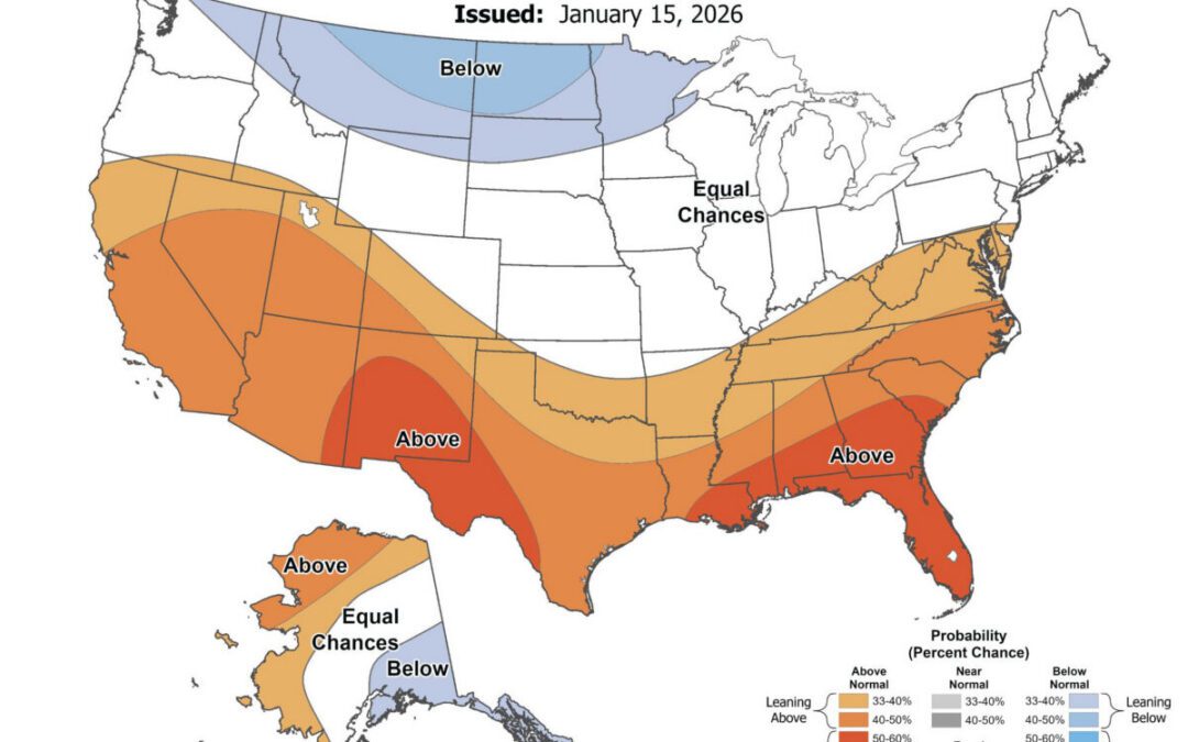
Will it be a warm spring in NC? See NOAA 2026 long-range forecast
Just over a month before the official start of spring, here's what weather forecasters are predicting for NC. As we head into February, the National...

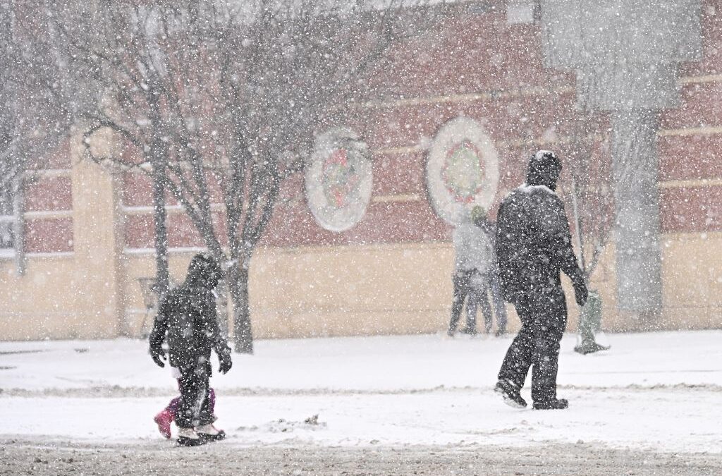
Arctic blast incoming to North Carolina. Will there be snow or ice?
North Carolina will experience a deep shot of Arctic air this weekend, bringing frigid temperatures, gusty winds, and pockets of snow across the...
What a bomb cyclone is—and why North Carolina keeps seeing extreme weather
Back-to-back winter storms are testing North Carolina’s power grid. Across North Carolina, the signs of another winter storm were hard to miss: snow...
What a bomb cyclone is—and why North Carolina keeps seeing extreme weather
Back-to-back winter storms are testing North Carolina’s power grid. Across North Carolina, the signs of another winter storm were hard to miss: snow...
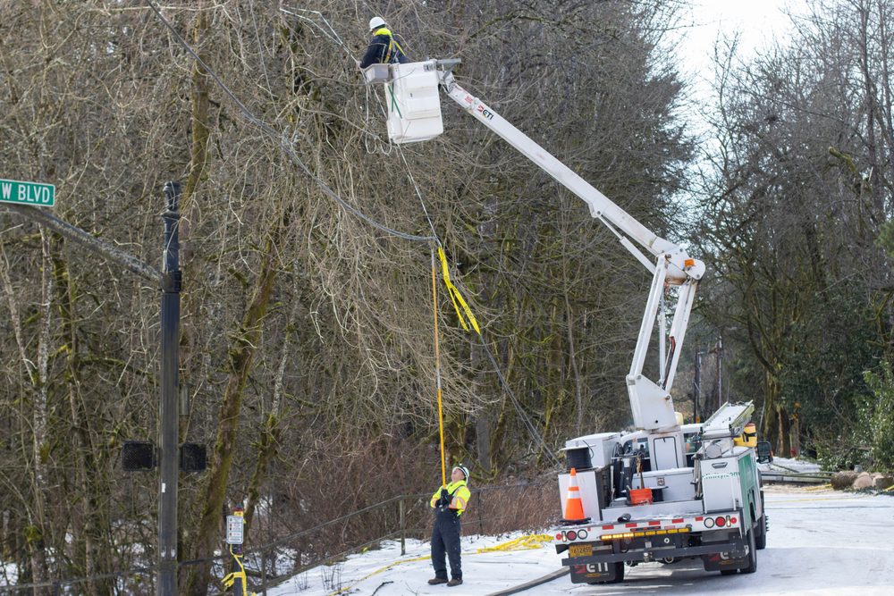
Everything you never learned about NC’s power grid—and how clean energy fits in
What keeps the lights on during winter storms has less to do with forecast, and more to do with how the state’s grid is designed. When Winter Storm...