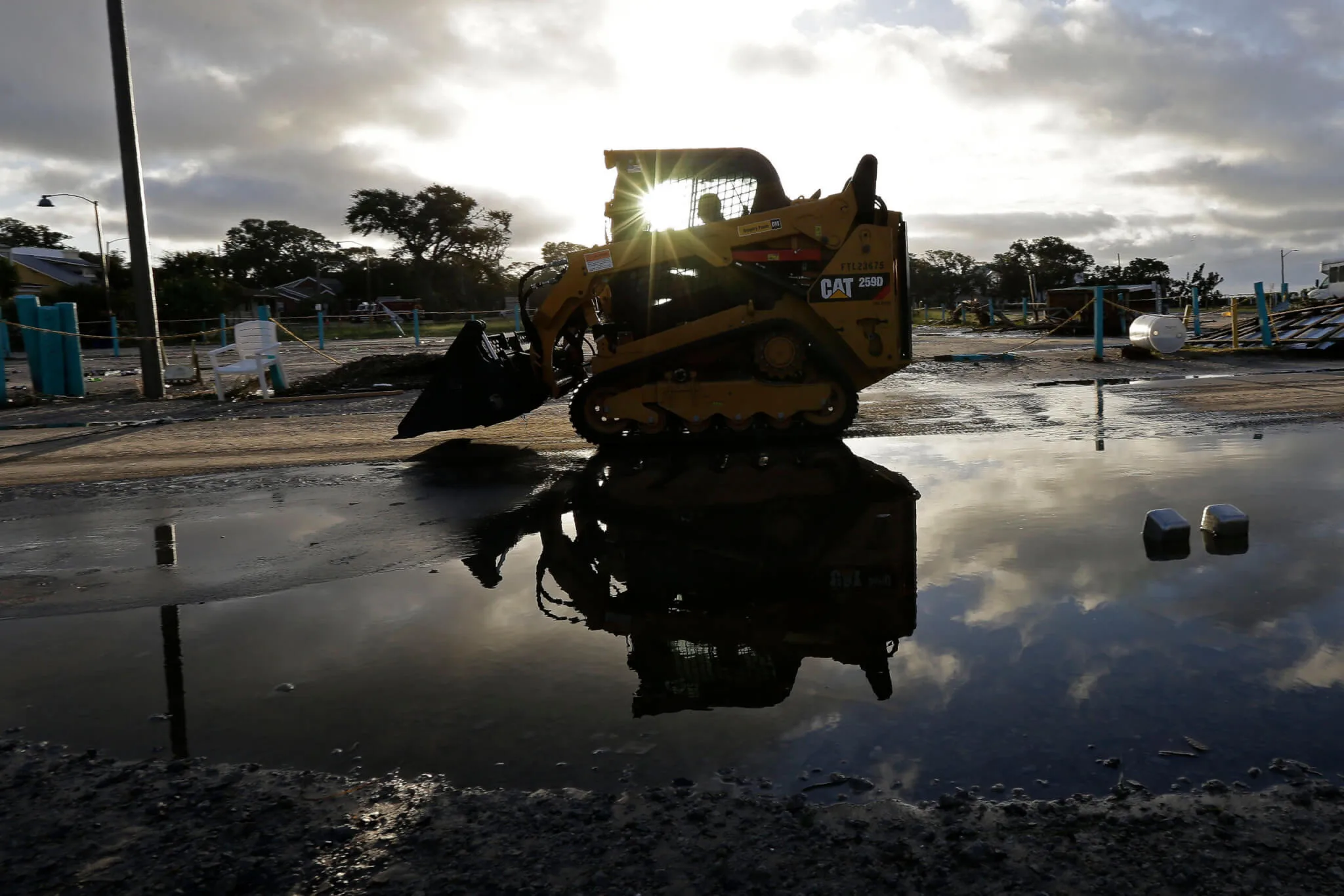
Cleanup begins following the effects of Hurricane Isaias in Southport, N.C., Tuesday, Aug. 4, 2020. The storm is past but researchers are expecting an extremely active hurricane season. (AP Photo/Gerry Broome)
Isaias is past, but researchers are predicting an ‘extremely active’ hurricane season for NC, with climate change and warmer seas playing a part.
When Hurricane Isaias slammed into the Brunswick County coast on a full moon near high tide Monday night, the storm battered beaches and low-lying areas with fierce winds and a 5-foot storm surge.
As of Thursday, reported death and injuries due to the storm system were low, but wind and water damage has yet to be calculated. Drone footage from Tuesday showed heavy damage to Oak Island, and the state remains under elevated threat for minor downstream flooding later this week.
In a press conference on Tuesday afternoon, Gov. Roy Cooper praised state and local emergency officials’ preparedness for the storm, The Raleigh News & Observer reported.
The state’s pre-emptive steps included declaring a state of emergency, activating the National Guard, and readying swift-water rescue teams throughout North Carolina’s coastal areas. Cooper said that swift-water teams had rescued two people from a flooded home in Bertie County.
‘Don’t underestimate what looks like a weak storm on paper.’
That said, residents of southeastern North Carolina, who have grown familiar with storms, may have underestimated the amount of water moved by Isaias, the governor stated.
“They were somewhat surprised at the amount of storm surge, the fact that it was high tide, the fact that this storm did strengthen and become Category 1,” the governor said. “I think that they had not expected that much water in Brunswick County.”
Indeed, the chairman of the Brunswick County Commissioners, Frank Williams, told Star News Online that some county residents may have underestimated the storm’s destructive capabilities.
“I think this one surprised us,” Williams said. He stressed that although Isaias was a relatively weak system, it did more damage to Brunswick County beaches than bigger and more powerful hurricanes like Matthew in 2016 and Florence in 2018.
“The lesson is don’t underestimate what looks like a weak storm on paper,” Williams offered.
Duke Energy spokesperson Jeff Brooks estimated 70% of customers in New Hanover County lost power, with close to 65% in nearby Onslow County losing power as well.
“For lack of a better word, it was hell.”
“Wind-wise, this one at times was right up there with some of the bigger storms,” Brooks told Star News Online. “This storm was a fast-mover and one that didn’t leave a lot of flooding behind in most areas, but it did deliver a powerful punch in the areas where it came ashore.”
Isaias left massive power outages in its path, Star News Online reported. As of Thursday, more than 365,000 customers in mostly southeastern North Carolina were without power.
Localized cells of high winds turned deadly when they spun off multiple tornadoes.
According to WXII, The National Weather Service confirmed five tornadoes impacting North Carolina, including two in Brunswick County and one in Beaufort County.
Another storm-spawned tornado ripped through a mobile home park in Bertie County, leaving a man and a woman dead amid a swath of wind-driven destruction. A nearby resident told WRAL that she hid in her bathroom with her two sons while the tornado passed.
“We didn’t have a lot of time to react once it finally hit,” Desaree Pike said. “For lack of a better word, it was hell.”
Fierce hurricane season ahead?
As state officials and residents assessed Isaias’ impact, many wondered if North Carolina is fully prepared for what may be one of the most severe storm seasons in recent history.
Hurricane Isaias is the fifth storm to make landfall this season, and it hit about two weeks sooner than usual, CBS News reported Thursday.
In addition to being two weeks ahead of record pace, the storm season will also be “extremely active” according to the research team at Colorado State University (CSU).
On Wednesday, the CSU team predicted 24 named storms for the 2020 season, including 5 major hurricanes among a total of 12 hurricanes. Each of those figures are double that of a normal season. If CSU’s forecast is accurate, 2020 would mark the most active Atlantic hurricane season since 2005, when Hurricanes Katrina and Wilma devastated the Gulf Coast and Florida.
UNC-Charlotte graduate student Eric Webb provided one possible reason for these larger and more powerful storms arriving ahead of schedule. Webb created a map showing Atlantic sea surface temperatures at near historic levels.
At these high temperatures, tropical Atlantic water can act like fuel to power hurricanes, Webb maintained.
While this hotter-than-usual water is driven by a natural cycle called the Atlantic Multidecadal Oscillation (AMO), it is bolstered by human-caused climate change. Human warming has increased tropical Atlantic sea surface temperatures by about 2 degrees Fahrenheit since 1901, said Webb, who specializes in tropical weather.
In addition, Webb noted, African rainfall, which spawns the incipient tropical storm systems that can become hurricanes as they cross the Atlantic Basin, is far above normal.
“The African Sahel region (between the Congo rainforest to the south and Sahara Desert to the north) has been really wet this summer,” Webb explained. “A wetter African Sahel means that the waves which create up to 90% of the Atlantic’s intense hurricanes are stronger.”
Despite the forecasts, CBS News reported that states along the Atlantic seaboard will be getting a short reprieve. For the next 10 days, conditions in the Atlantic Basin will be unfavorable for the development of hurricanes. This will give residents of hurricane alley, including North Carolinians, a brief opportunity to plan.
Starting in mid-to-late August, the pattern will shift again to become favorable for storm development. Given the accelerated and turbo-charged rate of the 2020 season, those storms will likely start coming faster and more furious.
With many states and cities battling COVID-19, CBS advocated that seaboard states start using the 10-day respite to prepare.
In North Carolina, there’s no evidence that Cooper has been apprised of Webb’s & CSU’s findings, but he has already advocated pre-planning for hurricane season.
“We don’t have the luxury of sitting back and seeing how hurricane season goes. That’s especially true during a pandemic,” Cooper said Tuesday. “Our state has recovered from some fierce storms over the years. As we pick up the pieces today, let’s harness that spirit of recovery and resilience that has gotten us through tough times before.”
Politics

Emergency rooms refused to treat pregnant women, leaving one to miscarry in a lobby restroom
By AMANDA SEITZ Associated Press WASHINGTON (AP) — One woman miscarried in the lobby restroom of a Texas emergency room as front desk staff refused...

‘Unfit to be our next governor’: NC basketball greats speak out against Mark Robinson’s run for governor
NC has a long history of greatness on the basketball court. Now college basketball players from UNC, NC State, and Duke are wading into politics....
Local News

Good News Friday: It’s a good day to be a fan of the NC State Wolfpack
The men's and women's teams will compete for a national championship in college basketball this weekend. Plus: How to watch the solar eclipse, and...

The zodiac signs of 12 iconic women offer insight into their historic accomplishments
Zodiac signs can tell you a lot about someone’s personality. Whether they’re an earth, water, air, or fire sign, these 12 categories (which are...


